Monday

Day #85. September 11.

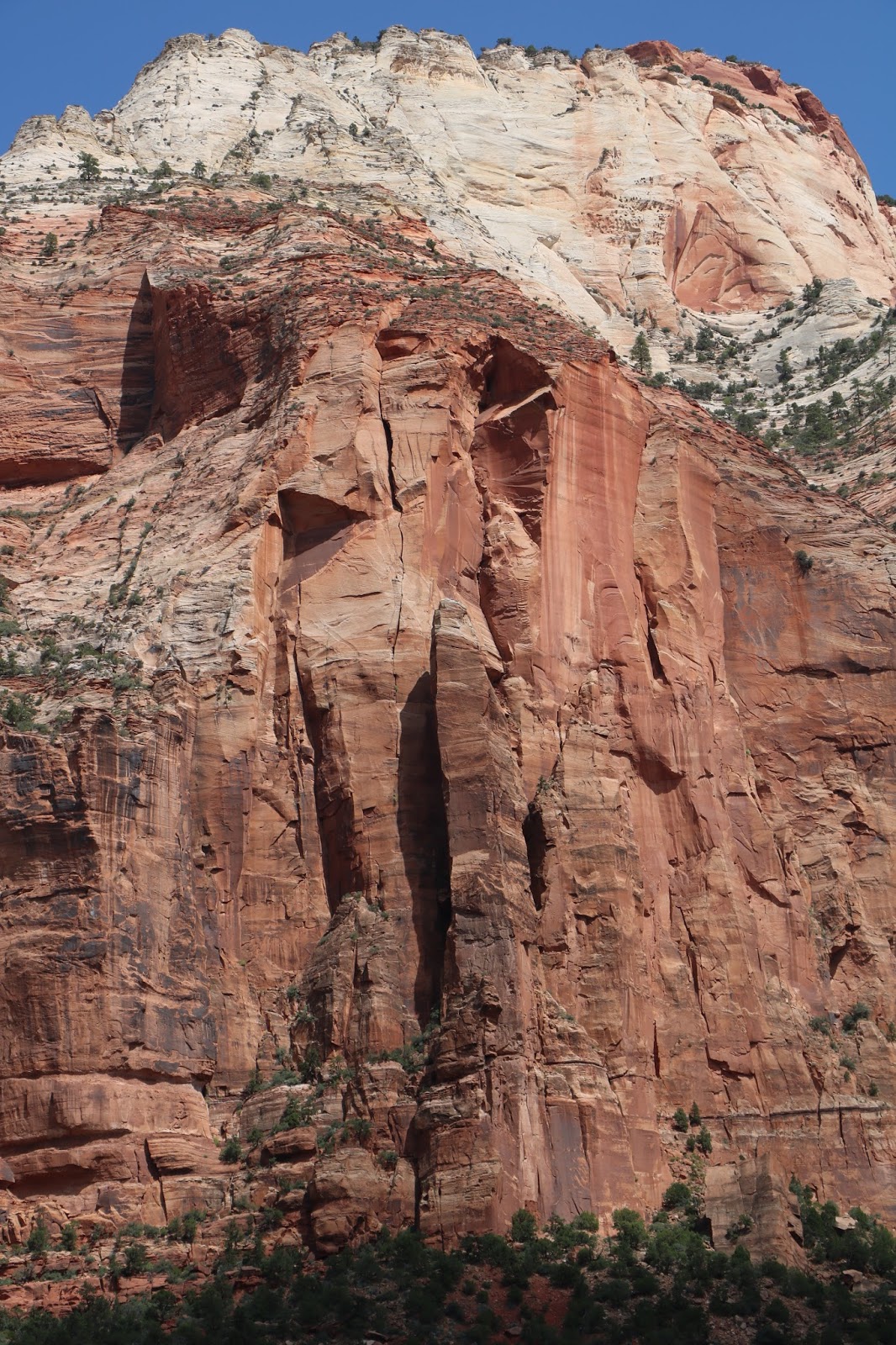
We came into Zion from the east on Saturday by way of the Zion Mount Carmel Highway and traveled for twenty-five miles to the southern entrance, through the most spectacular country we have seen in this region. Much of the park is inaccessible by car but the main road follows water courses that carve their way through amazing landscape including mountains, canyons, buttes, mesas, monolithic rock formations and natural arches.

Definitely Monolithic


Standing at the Base of a Thousand Foot Monolith

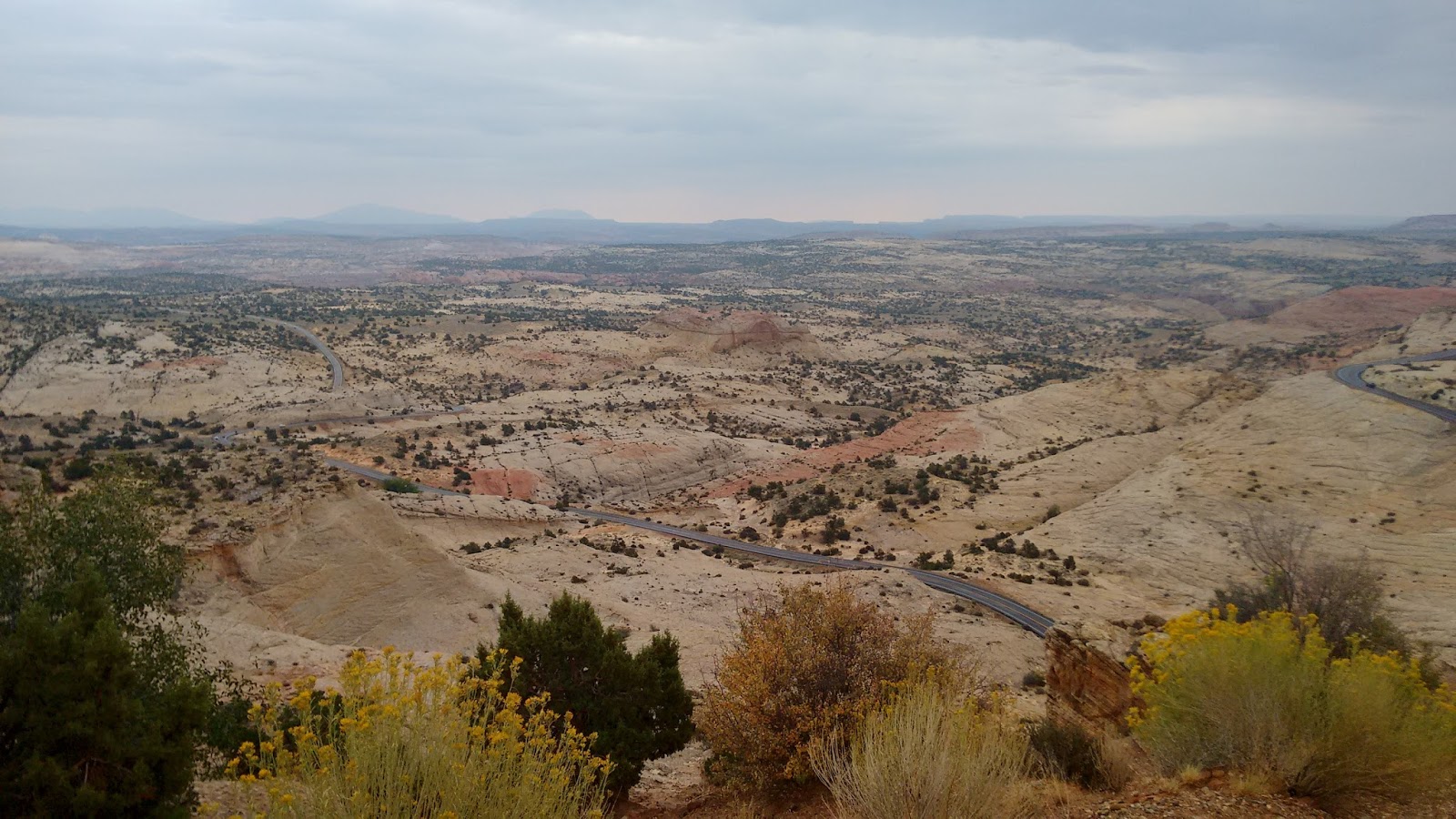
On Sunday morning from our ‘Ant Haven’ campsite, we drive north from Virgin, UT (population 600) onward and upward alone a terrace or shoulder of the Kolob Plateau with Zion National Park to the immediate east. Finally, to the remote Kolob Reservoir and the community of Kolob. Fifteen houses, a community center and no services. Folks up here use propane to power refrigerators and catch water in cisterns. Fifteen feet of snow annually. The state or county does not plow Kolob Terrace Road so if you are here after the first snows come, it’s here you stay unless you walk out or get a fat guy with a snow mobile to come pick you up.


On Our Way Up on Kolob Terrace Road. Zion Canyon in the Background.
 
Oasis in the Desert. Lava Terraces on Kolob Road
 
On the way out, we stop at Under Canvas, where one can stay in one of many ‘luxury’ tents, to do a little 'glamping'.
A new one on me, glamping is the opposite of 'roughing it'. The ‘base model' starts at $385/night. I think I’ll stick with our Little Guy.


Under Canvas 'Glamping" Hotel

You Can Rent This Tent for $385/Night. The Rocks are Free.
A New Friend

On the Kolob Plateau


We drive back through Zion for a trolley ride through the North Fork of the Virgin River. Wow! Wow! The NF Virgin flows out of Zion and joins the East Fork Virgin in Rockville to form the main stem of the Virgin River, which magically becomes clean and clear because of all the yuppie, hippie, organic living folk there. From there the Virgin flows southwestward through St. George, UT, Littlefield AZ and Mesquite, NV to finally join Muddy River and the Colorado. Together these rivers artificially form Lake Mead thanks to Hoover Dam, another Bureau of Reclamation monstrosity.

Virgin River Zion Canyon Scenes


Like much of the Grand Staircase Escalante archaeological evidence shows inhabitation by the Anasazi people about 1000 years ago, the Fremont people and finally those pesky Paiutes. Then came the Mormons.

Geologically speaking, this region used to be a vast, warm, shallow sea. Thirteen million years ago tectonic forces uplifted the region to ten thousand feet to create the Colorado Plateau. Since then rivers and streams have eroded the landscape into the deep and vast canyons we see today.


Extremes in altitude and water regimes created desert, riparian, woodland and coniferous forest habitats that sport 290 birds, 80 mammals, 28 reptiles, 7 fishes and 6 amphibians today, not to mention scores of plants and hundreds of insect species.
“Immutable yet ever changing, the cliffs of Zion stand resolute, a glowing presence in late day, a wild calm. Melodies of waters soothe desert parched ears, streams twinkle over stone, wren song cascades from red rock cliffs, cottonwood leaves jitter on the breeze.” Credit - some guy or gal in the National Park Service.


See https://www.nps.gov/zion/planyourvisit/upload/ZionUnigrid.pdf for more on Zion.

Back to the Ant Haven for the night. Tomorrow headed for Gold Butte National Monument. 

Sunday

Day #84. September 10.


Drove through Bryce Canyon National Park then south on route 89 into Zion national Park, the big door prize. Bryce and Zion are part of the Grand Staircase Escalante, not the proscribed national monument but the broad geologic formation of this region.
On the Way to Bryce Canyon National Park

Look at https://upload.wikimedia.org/wikipedia/commons/c/c5/Grand_Staircase-big.jpg for an excellent depiction of the Grand Staircase.
Imagine a wedge shaped plain about one hundred miles long trending highest in the west to lowest to the east. Over two hundred and seventy-five million years water and wind has cut deep, long, magnificent meandering canyons, sculpted the sparsely vegetated surface of the plain and its canyons into spires, towers, buttes, mesas, needles, arches and all manner of other weird and wonderful geologic features. The Escalante and Colorado Rivers are responsible for this grand mess.


Lots of Needle Capped Arches in Bryce Canyon

In addition to this majestic geology, one finds rich archeologic evidence of ancient First Peoples like those pesky Paiutes.

Needle Formations, a Bryce Signature

Depending on where you stand the rock is fifty to two hundred and seventy-five million years old. Four bands of north to south trending impressive cliffs about twenty miles apart define elevation changes, define the edges of a series of plateaus. Moving from west to east, from younger to older rock strata and from higher to lower elevations, Pink Cliffs, Grey Cliffs, White Cliffs, Vermillion Cliffs and Chocolate Cliffs exhibit colors of those different strata.  And thus, the name Grand Staircase for the whole assemblage, as the cliff bands are ‘steps’ along the west to east progression.

The Splendid Grand Staircase Escalante

In order from west to east, Bryce, Zion and the big kielbasa, the Grand Canyon, the grandest of them all, along with hundreds of associated smaller canyons, slice and dice the plateaus into an intricate and remote rock wilderness. So remote and inaccessible that the Grand Staircase was the last region of the lower forty-eight states that cartographers nailed down.


Today the region is road free except for four-wheel drive ‘jeep’ trails. It’s a big empty playground for young, strong hikers, climbers, ‘canyoners’ and fat guys in big off-road machines. Let’s not forget the three hundred species of amphibians, birds, mammals and reptiles living in the Grand Staircase Escalante including mule deer, mountain lions, cougar, bighorn sheep, elk and even some bears.


With two-wheel drive, Emily and I can only nibble at the edges of the Grand Staircase.

On to Zion National Park. Oh my!. We enter Zion from the east and drive through to the southern side and finally to Rockville, UT, the mother of all tourist traps, where one can spend one's money on all manner of glitzy, organic, gluten plastic, salt, sulfite, preservative, antibiotic free, free range, artisan, locally grown bull shit imaginable.

Zion is magnificent, sublime, smashing, splendid. Not enough adjectives to describe this place. I'll let a few pictures speak for themselves.


This night we camped on Kolab Terrace Road on North Creek on BLM Land, where there was an ant convention, with representative ants from all over the world in attendance it seemed. Nowhere to camp except right in the middle of the convention.


Our Campsite for the Night. Ant Haven


Saturday

Day #83. September 9.


Three mule deer in campground this morning. Rainy and chilly day.

Henry Mountains in the Background

Traveling through the two million-acre Dixie National Forest, straddling the Great Divide between the Great Basin and the Colorado River, down a narrow shoulder of Boulder Mountain with a summit at 11,322 feet. Steep drops on each side down to spectacular red rock canyons.
Deep Canyons.

Those are Five Hundred Foot Walls

Vegetation is sparse; desert plants at the lower elevations, low-growing pinyon pine and juniper higher and aspen, pine, spruce, and fir higher still. Aspen turning yellow now in spots. Fall coming. Lots of open range cattle.


The high plateaus of Southern Utah are rich with pictographs, petroglyphs, dwellings, and artifacts of ancient people. First nomadic hunters and gatherers and later the Fremont and Anasazi, more sedentary and agricultural. Anasazi stone huts, "Moqui Houses", remain to this day on high ledges throughout the region.

Clannish Paiute Indians ranged this country when the first European settlers arrived in the late 1700s. Spaniards established the Old Spanish Trail and opened trade with local Indians, primarily trading horses for Indian slaves. Fair enough trade, right?  The Spanish Trail became known as the Slave Trail. Fitting.
Our Road

More trappers, traders, gold hunters, and adventurers followed. These early Europeans had to put up with marauding Paiute Indians. Imagine the nerve of those pesky Paiutes. 

High on this mountain shoulder we have splendid views of the Henry Mountains to the east with Mount Ellen at 11,500 feet. The Henrys, the last mountain range cartographers added to the map of the lower 48 states, are named in honor of Joseph Henry, the first secretary of the Smithsonian Institution.  I bet those pesky Paiutes have a different name for them.
Glen Canyon to the southeast. The two-million-acre Grand Staircase Escalante National Monument to the south. At least it was two million acres until President Bone Spurs came to office and promptly cut it by fifty percent. More on Escalante later. Bryce Canyon to the west. More magnificent landscape.

Downward, downward. Into Boulder, UT (population 225). Crossed the Escalante River and came into the town of Escalante (population 797).

A Juniper Tree and my Little Juniper

Needles

Sticking to route 12, bound for Bryce Canyon National Park. Traveling through Henrieville (population 225), Cannonville (population 167), Tropic (population 530) and finally to Bryce.

Found good dispersed camping on Tom Best Spring Road west of Bryce.

Tomorrow Bryce Canyon.
More Pictures


Friday

Day #82. September 8.

Off and away from Bridges. 275 to 95. Circle to the south and then northwest into Fry Canyon. More canyon country; broad vistas, mesas, towers, high cliffs, red rock sandstone.


And suddenly, Glen Canyon. Oh my! Miles and miles and miles of the grandest landscape yet. More striking, uninterrupted red rock formations with minimal vegetation. The main canyon and many beautiful side canyons. Lake Powell covers much of the main and many of the side canyons.


Lake Powell is one of the largest man-made lakes in North America. One hundred and eighty-six miles long, with nineteen hundred and sixty miles of shoreline at maximum pool volume, and over ninety-six major side canyons. Just think how many Native People’s archaeological sites are underwater along with evidence of early European explorers and settlers. In relatively short geological time, Lake Powell will fill in with sediment and those archeological wonders will be cemented and fossilized in Colorado River mud, for future archeologists to discover and wonder about. 
Like Hite, UT for example.
Hite is a tiny community at the northeast end of Lake Powell. Five houses, a seasonal general store, a ranger station, a little used private campground and an abandoned marina. But the original Hite is an underwater ghost town, thanks to the Glen Canyon Dam.  Prospector Cass Hite came to the area in 1883 looking for gold, which he found in the sands and gravel along the Colorado River. He built the first structure here; a cabin of notched logs salvaged from the River and established a post office in 1889. Horse riders brought in the mail from Green River, one hundred miles away.
The sparse gold deposit played out, but Cass and his brothers operated a small store that sold Chinese junk and drug paraphernalia to miners and others passing through. In modern times, other people figured to make a fortune by building a marina to serve a future boating crowd. Nice idea but nature has its way. Water level in the lake dropped considerably because, well, it’s a desert. In addition, as the Colorado River slows down when it enters the still waters of the Lake, it drops its sediment. As a results, today you can practically walk across it. Not good if you own a marina. Eventually Lake Powell will fill in with sediment, Glen Canyon Dam will breach and the mighty Colorado will erode another grand canyon. 
We cross the Colorado, on route 95, the only bridge over the Colorado for 300 miles between the Glen Canyon Dam and Moab. Then the Dirty Devil River that also feeds the Lake. This is the same Colorado of course that flows through the Grand Canyon then into Lake Meade, the other large lake on the River, made by the monstrous Hoover Dam.
Route 95 Bridge Across the Mighty Colorado

High Above the Route 95 Bridge on the Colorado River

We travel on 95 along the western edge of the upper reaches of the Lake  then turn northwest and travel to Three Forks, then Hanksville, UT (population 219) just south of the confluence of the Fremont River and Muddy Creek, which together form the Dirty Devil River. In Hanksville we pick up westbound route 24. Henry Mountains (named after my son, Henry) to the south. Hanksville is situated on the Colorado Plateau which sports a cold desert climate, a mean annual temperature of 52 degrees Fahrenheit and an annual mean rainfall of 5.5 inches.

Hanksville, UT Condominium 

My Sentiments Exactly

We turn south on 12 at Torrey, UT (population 182) and drive to Oak Creek Campground in the Dixie National Forest. A long day. We are the only people here. Nearby wild turkeys, mule deer and a jack rabbit. Good eating!
And good night!

More Scenes on the Way to Oak Creek Campground


Wednesday

Day #81, September 7


We leave Canyonlands and head east on 211. Rounding a turn near Newspaper Rock we see a flock of twenty wild turkeys, big fat females and some chicks. Lord only knows what they eat out here! Probably lots of insects.

Sunup at Canyonlands, Squaw Flats Campground

We turn south on 191 and drive through Monticello, back through Blanding and pick up 90 west bound. Very little traffic out in these parts. A few cars and trucks. Just north of Black Mesa Butte a highway flagman, or should I say flag woman, stops us. Here we sit for about forty-five minutes. Excellent opportunity to strike up a conservation. Her name is Theresa Yuza Singer, a full blood Navajo native, Mormon and card-carrying member of the Church of Latter Day Saints. Every week she drives from the Navajo Indian Reservation further to the south close to Mexican Hat where she has a family, a husband and children. She lives in her car during the week to be close to her work and returns at week’s end. Time for me to quit complaining about the small shit.

On the Way to Natural Bridges National Monument


We drop from Black Mesa Butte, cross a deep, dry canyon and enter the Manti-La Sal National Forest, a remote 1.2-million-acre area centered on the La Sal Mountains, the second highest mountain range Utah, near Bears Ears National Monument.

We leave 95 and head over to natural Bridges National Monument. Another hidden gem on the American Western landscape. Infrequently visited and no less spectacular than many of the parks we have visited. In time to do a little exploring in Bridges and Bears Ears. Nice campsite overlooking canyon country.

Natural Bridges National Monument Views


I had forgotten to mention that when we camped at Hovenweep Monument we had met a fantastic young couple from Oklahoma City with whom we had shared maps. They were both geologists and were traveling around on a vacation doing what we were doing. And, as luck would have it, here they were at this campsite.

Our Geologists Friends, Vigorous and Fit, Returning from the Canyon Bottom

Bears Ears National Monument


Beautiful clear star-studded night in canyon country. Good night all. Tomorrow Bridges and Bears Ears.