Monday

Day #95. September 21.

Hello folks. I'm going to try something today. Click on the link below that will take you to a map of todays places.

Day 95 September 21 Map

We leave the Organ Mountains Desert Peak campground after a hearty breakfast and the lifesaving coffee fix. Saw a coyote on the way out and two batteries of Gamble’s Quails, native birds of this hot, dry Sonoran Desert country. These beautiful creatures do not migrate, rarely fly and spend their days scurrying about in brushy desert undergrowth, foraging on grass, shrub, cactus and tree seeds and gobbling up insects, spiders and small reptiles. Yum! Yum! Nothing better than insect, spider and reptile stew.

Gamble's Quail Habitat

We travel northeastward and descend into the Chihuahua Desert Tularosa Basin, out of which no water flows and into which very little water flows. The only other water input to the Basin is a paltry ten inches of precipitation a year, most of that coming during the ‘rainy season’ from July through September when day time temperatures can rise to 110 degrees F. 
We Are Talking Real Desert Country

What does not sink into the porous, salty, high mineral content, alkaline soil evaporates in this withering heat, so there is very little surface water aside from a few shallow, salty, seasonal lakes. That means that this is a hot, damn dry, harsh, foreboding place. Despite these austere conditions, before Anglo settlement certain parts of the basin supported lush and nutritious, native grasslands that could grow five feet tall in wet years.

The Mescalero Apache were here first.

Hispanic farmers showed up in 1862.

The US military charged onto the scene with their repeating Spencers to protect the Hispanics from those pesky Mescalero Apaches.

Anglo cattlemen and farmers invaded in the late 1870s. Their cattle, lots of them, overgrazed the grasslands and most of the rest of the basin, causing severe top soil erosion.

The Mescalero Apaches ate more peyote and laughed.

With very little surface water available for crops the settlers tapped the shallow fresh water aquifer. That fresh or ‘sweet’ water, as it’s called, was floating on top of brackish water.  Once the fresh water was gone, which didn’t take very long, the wells pumped brackish water, which when applied to the soil, concentrated salt and gypsum minerals even more. That higher salt content surface water flowed back into the aquifer in a never-ending cycle of increased salt concentration.

Farmers continued to pump ground water and irrigate this way well into the late twentieth century. Once the cycle starts it is very hard to reverse. This increase in ground water salinization has occurred in many other areas in western states when industrial farmers pull ground water from aquifers and use it to irrigate high mineral content soils. Over time some cultivated areas are too salty to farm.

In 2004 the federal government started the Tularosa Basin National Desalinization Research Facility at Alamogordo, a joint project of the Federal Bureau of Reclamation and Sandia National Laboratories. Scientists working at these federal facilities are researching procedures to reverse soil salinization and creation of brackish water.

Guess who pays for that. You can bet it’s not the conservative leaning, well-heeled industrial, agricultural interests, who give generously to their congress men and women, who would never vote for a piece of favorable legislation just because someone gave them a little ole campaign donation. Sound familiar?

Enough proselytizing.

On we go to the White Sands National Monument, part of an eye-popping 275 Tularosa Basin square miles of white sand dunes comprised of gypsum crystals.

White Sands National Monument Gypsum Flats
Gypsum Dunes

Gypsum is a water-soluble sulfate salt complex found in great abundance in the mountains ringing the Tularosa Basin. If the Basin had an outlet to the sea over geologic time the gypsum would dissolve, and surface water would carry it to the sea. Since it does not, the gypsum ladened water evaporates in the wilting heat, leaving vast gypsum deposits in the form of crystals, some reaching three feet in length. Prevailing winds erode the crystals down to sand-grain size particles and whip them up into impressive dunes, which support all manner of interesting plants and animals that ride along as the dunes migrate downwind.

Soap Tree Yucca

Interestingly enough, even in the hottest summer months, one can walk on gypsum 'sand' barefooted, because, unlike dunes made of quartz-based sand, gypsum does not convert the sun's energy into heat. 

Big Gypsum Dune

Just to make things interesting, the White Sands Missile Range lies just to the north of the Monument, where our government tests new and innovative weapons of mass destruction to stay one step ahead of the Russians and Chinese. We think?

The Mescalero Apaches eat more peyote, but they are not laughing.

From White Sands we travel to Alamogordo (population 30,000), mostly retired military folks, near Holloman Air Force Base.  Close by, on July 16, 1945 the US government conducted the Trinity test, the first test in the world of a nuclear weapon, a progenitor of the bomb dropped on Nagasaki, Japan on August 9, 1945.

They didn’t waste any time on that one, did they?

We head out from Alamogordo on 54 north, mesmerized by this vast desert country. White Sands Missile Range just to the west, the Mescalero Apache Indian Reservation just to the east. A right turn  takes us 15 miles along a hard packed dirt gravel road to the Three Rivers Petroglyph Site, where one can find 21,000 separate and distinct petroglyphic rock art carvings of masks, sunbursts, handprints, birds, humans, animals, fish, insects and plants, as well as numerous geometric and abstract designs dating back to about 900 to 1400 AD, when Jornada Mogollon people ate some peyote, took another toke and used stone tools to remove the dark patina on the exterior of the basaltic rock and carved these remarkable images.

Petroglyphs on Basaltic Rock


If these folks were not eating peyote I just don’t know!


Hot dry Country Around Three Rivers Petroglyph 

Back out to 54 and north on Three Rivers (population 10 near as we can tell), Oscura (population 10 ghosts), Polly (population 6 ghosts) and finally to Carrizozo (population 1000 live people) where we gas up with a burrito at the Carrizozo Café, which helps us fart our way west on route 380 to our final destination for the day, the magnificent Valley of the Fires.


The Malpais Lava Flow, a four to six miles wide, 160 feet thick, 5,000 years old sculpted basaltic monolith covering 125 square miles, thought to be one of the youngest lava flows in the continental United States. The flow originated from Little Black Peak, about ten miles northwest.
Five thousand years ago the lava flow was barren but nature and time painstakingly decorated it with flowers, cacti, trees and bushes, bats, roadrunners, quail, cottontails, mule deer, barberry sheep, lizards, great horned owls, burrowing owls, turkey vultures, hawks, gnat catchers, cactus wrens, sparrows and rattle snakes, lots of rattlesnakes.

Lava, Lava Everywhere

Trail Leading Into The Lava Flow


There is a Bureau of Land Management campsite here, situated on a high bluff overlooking the lava flow with isolated individual sites and fabulous views of the Tularosa Basin in every direction, picnic shelters, tables, grills, potable water and hot water showers, for five dollars a night for us poor old folks.

Windy, windy, windy! 

More Scenes in the Valley of Fire
Cane Cholla, Valley of Fire

An Ancient Juniper and My Not So Ancient Sweet Juniper

Lava Gas Bubbles

Lava Flow

Sunset Over The Valley Of Fires

Sunday

Day #94. September 20.


Woke up to hummingbirds in our campsite. Did not get an ID.

We decide to return to Las Cruses to do some business. 

Las Cruses, ‘City of the Crosses’. People say that an unknown Spaniard named the city to honor local bandits buried in hilltop graves protected by three wooden crosses. I like that. Honor among thieves.
Before the Spanish, there were the Manso Indians living in the Rio Grande Valley, with Mescalero Apache nearby. The Spaniards showed up in 1598 and, as Europeans are wont to do, claimed the region for themselves. Mexicans came in 1821 and claimed it, saying it was theirs in the first place. Then those gun toting, upstart Americans from the Republic of Texas, owing allegiance to no one, stepped in to claim it. Then America went to war with Mexico and took control after that.
The Manso and Mescalero ate some more peyote and laughed.

The Santa Fe Railroad came through in 1860 bringing the hoards.

Pat Garrett came to town in 1880 and killed Billy the Kid in 1881.

Emily and I arrived in 2017 and I haven’t killed anyone yet.

We get medicine, ice, gas, liquor, oil change, spare tire and have a great lunch at La Nueva Casita. Second best burrito in the world. Then return to our Desert Peaks refuge for another pleasant and restful evening.

Tomorrow, White Sands National Monument.

Namaste.

Desertscape at Organ Mountain Desert Peaks National Monument

Saturday

Day #93. September 19


Last night, as we lay contentedly in our bunks, we heard yipping coyotes and the deep, rich “who-hoo-hoo-who” of a Great Horned Owl making sure we knew he knew we were near his territory. I like to think that if he saw the tiny camper we live in he would feel less threatened. I like to think he is saying to himself, “these people can be that bad, surely not as bad as those idiots in those huge RVs that were here last weekend”.

The Great Horned Owl ranges over all of North, Central and South America looking for love and rabbits, hares, mice, rats and voles to munch on. Just like we do, but we tend to chicken, pork and pasta.
The American Pima Indians, whose ancestral stomping grounds include what is now Central and Southern Arizona, believed that owls were reincarnations of slain warriors who fly about at night. Peyote probably helps with this poetic approach to life.  

After a life reviving coffee fix away we go northeast on 90 through White Signal, NM (population 181), Oak Grove, NM (population 0) and finally to the outskirts of Silver City, NM (population 10,000) where we see the Tyrone B Complex, an enormous large open pit copper strip mine, part of a complex of copper mining sites in the area. Tyrone A Complex lies just northeast of Silver City. Together these mines sit on the second largest documented copper deposit in New Mexico. 


Tyrone Mine Complex B. These pictures do not begin to convey the enormity of this landscape scar.


Freeport-McMoRan Copper and Gold, Inc. operates the Tyrone mines. Various companies have used open strip mining techniques here since 1968. Before that, in the early 1860s, brave souls mined in dangerous, hand dug tunnels. Before that, way before that, around 600AD, Native Americans, who were smart enough not to make dangerous holes in the ground and crawl in them, surfaced mined turquoise.

In 2003, Freeport began reclamation activities at Tyrone; to cleanup tailings, acid water, impoundments and waste rock. They have been at it ever since. No wonder copper pipe is so expensive. Damn those onerous, nitpicky, environmental regulations. Not to worry. Scott (“I don’t give a damn what people think, I’m flying first class”) Pruitt, Environmental Protection Agency Administrator from hell, is taking care of that for President Bone Spurs.

We drive into Silver City, home of the Western New Mexico University Mustangs. Silver City was once an Apache campsite, then Spaniards showed up, evicted the Apaches or got them so drunk it didn't matter whether they were there or not, chased off those itinerant turquoise hoarders and started mining copper. Then the usual band of American prospectors, responding to rumors of the discovery of silver, showed up bringing rot gut whiskey, guns and more guns, prostitutes, disease, violence and mayhem. The silver played out and the violence got worse.

In 1874, a new cop, Harvey Whitehill, Grant County Sheriff, came to town and put the kibosh on all the fun and games. In 1875 he arrested Billy the Kid, arrested him twice in fact, both times for theft. Billy frequented Silver City often. His mother, Catherine McCarthy, an Irish immigrant, resides in a grave there. I bet she lived a 'colorful' life.

In 1878, the town hired its first town marshal, “Dangerous Dan” Tucker, who some claimed had stabbed a man to death in Colorado and killed others in El Paso and Santa Fe. In Silver City Dangerous Dan killed a drunk Mexican who had been fighting in a ‘dance hall’ and later, in the same year, tracked down and killed another drunk Mexican who had been throwing rocks at the good townsfolk.

Damn those drunk Mexicans. Texas Sheriff Joe Arpaio is, no doubt, proud of Dangerous Dan, for profiling and taking out those dirty, rapist, illegal, drunk Mexican immigrants. Wait, weren't they here first?

We poke around Silver City for a while and learn there is a thriving downtown artsy district with many musicians and music venues. Good news.

Traveling east on route 180 next we pass the Tyrone Mine Complex A (Chino Santa Maria Mine), another sprawling open pit, strip copper mine. Active mining going on, predicted to play out in twenty-five years. What are we going to use to make pennies then?

The Tyrone Complex A Santa Maria Mine. That is One Big Hole in the Ground.

Route 152 northeast through Hanover (population 167) and San Lorenzo (population 97) takes us through dramatic landscape in the Aldo Leopold Wilderness of the Gila National Forest to the summit pass at 8,185 feet. Very little traffic. Windy roads, precipitous drops.


Gila National Forest Scenes

Kingston, NM (population 32) is next and we cross Perchy Creek where we stop long enough to walk across the Perchy Creek Truss Bridge, now registered on the National Registry of Historic Places.

Perchy Bridge. Look at Those Lava Cliffs in the Background. 

Ancient Bridge Steele-o-glyphs by Drunk Mexican Rapist Illegals Carrying Black Water Bottles Coming to America to Take Our Jobs.


We descend to Hillsboro (population 1,000). Here we meet a ‘seasoned citizen’ in his store busy making custom leather chaps. He was gracious and very willing to talk with us. Not much else happening in Hillsboro. In fact he was the only person we see here today on our way through. Traditionally he has made the very nicely tooled and, in some cases, bejeweled chaps for cow pokes to wear to protect themselves from rattlesnake bites. Lately though he has found a new clientele. Harley riders. I suppose the bikers, as they poke along on their hogs minding their own business, are afraid that rattlesnakes might jump out of the creosote bush along the road, wrap themselves around the sunburnt, tattooed, legs of the innocent bikers and inflict painful bites. Distinct sweet odor of marijuana in the air in the shop. That makes chap making lots of fun I bet.

The Doctor Is In Hillsboro, NM. He Didn't Have a Lot to Say When I Told Him About My Troubles.

We continue on 152 and intersect with I25 south of Truth or Consequences, NM. Truth or Consequences got that name in 1950 when the town, named at the time Hot Springs, changed it to Truth or Consequences after Ralph Edwards, host of a popular radio quiz show by the same name, announced that he would air the program on its tenth anniversary from the first town to name itself after the show. Hot Springs won out. Edwards kept his word and, in fact, for the next fifty years returned to the town every year in May to broadcast the show again. The event became known as Fiesta and included a beauty contest, a parade and a stage show. To this day the good townsfolk still put on Fiesta. A mainstay event in recent years at Fiesta is the crowning of the Hatch ‘Chile Queen’.

We travel south on I25 alternating with parallel route 187 down the Rio Grande River Valley through Arrey (population 232), Garfield (population 132), Salem (population 942) and finally Hatch (population 1650).
People have tapped the Rio Grande for water to sustain life in this dry, hot country. A thirty mile wide green strip of Rio Grande River irrigated land stands in dramatic contrast to the bone dry desert beyond.   

And life for current residents in this hot, dry country means growing chilies. Chilies, chilies and more chilies. Throughout this portion of the Rio Grande River Valley the chili is king, queen, prince and princess. Green chilies, red chilies, white chilies, purple chilies, blue chilies. Big chilies, little chilies. Hot chilies, hotter chilies and atomic, ‘hot damn’ hot chilies. And tequila, lots of tequila to wash the chilies down. Just for diversity's sake they grow cotton, pecans and corn also, but not outside that verdant strip of irrigated land.  

Hatch is the ‘chili capital of the world’, thus the annual crowning of the Chile Queen at Fiesta.
All the local communities crown their own Chile Queens during harvest season and every year in the fall in Hatch the, by this time, drunk on chili laced tequila and sick to death of the summer heat townsfolk stage a mud wrestling contest featuring all the local Chile Queens, who duke it out for the top honor, to be this year's Supreme Chile Queen.

I just made that up.  But pretty good idea you must admit!

Flicka II forges on, down the Rio Grande Valley on I25 to Las Cruses, the ‘City of the Crosses’, then on route 70 east, ascending the San Augustin Mountains to the San Augustin Pass at 5,710 feet with the mighty Organ Mountains Desert Peaks just to the south.
We leave I70, turn on Aguirre Springs Road and enter the Organ Mountain Desert Peaks National Monument where we find a clean, delightful, Bureau of Land Management campground with breathing taking views of the Desert Peaks in the background to the west and equally as pleasing views of White Sands, NM to the east.

Whew! What a day.


Sunset Deepens the Color of the Organ Mountains Desert Peaks

Can't Get Enough of This Magnificent Country


Monday

Day #92. September 18.

Away we go north on 85 back to Why, AZ.

Why is Why, Why? you may ask. When Why didn’t have a name and a few earnest folks decided to live here, for what purpose I can’t imagine, highways 85 and 86 intersected in a Y. The local drunks, potheads, drug smugglers and other ne’er-do-wells lobbied for a post office, so they needed a town name. They had a meeting, smoked a doobie and offered up ‘Y’ as a logical choice. At the time Arizona required all cities to have at least three letters in their names, so the State vetoed ‘Y’. The townspeople took a pull on the tequila bottle and went to their second choice, ‘Why’, which the State approved. Since then, in its wisdom, the Arizona Department of Transportation removed the Y intersection for safety concerns.

With the Y intersection gone for a while, the good townsfolk forgot why Why is named Why. Your typical Why resident partakes of Mexican pot, tequila and cerveza often, which in and of itself creates a short term memory challenge. After all they do live in a desert where it rarely rains for months at a time and where daytime temperatures can soar to 110 degrees F. What else are you going to do to keep your mind clear? Bottom line, nobody can remember why Why is named Why. Which is why I am making up this story. And even if I didn’t make it up, I cannot remember why I didn’t.

At Why we take 86 E through the Tohono O’odham Indian Reservation, through Indian settlements; Schuchuli, Narcho Santos, Kui Tatk, Haivana Nakya, Pan Tak and others, all stuck out here in this hot, dry Sonoran Desert country. Mexico just a few scores of miles away. Many Border Patrol signs along the way issue warnings, cautions and advice, what to do and not to do when one sees ‘suspicious activity’, like dark skinned people walking across the desert on their way to visit friends and relatives and drug dealers.

Soon after getting on 86 we see Wile E Coyote hightailing it down a dry arroyo (gulch). And, I’m not making this up, soon after that we saw a road runner darting along through the desert and I swear he was laughing.

On we go to Tucson where we pick up I10 east and drive to Lordsburg, New Mexico (population 2,800) where, during World War II, the US Army held fifteen hundred Japanese Americans in an internment camp for one year. During that time a US soldier shot and killed two Japanese American internees, under questionable circumstances as the story goes. A military investigation concluded that the sentry killed the two internees lawfully. Let me get this straight. Its lawful to uproot and imprison US citizens who have not been charged and convicted of a crime and shoot them for acting up a bit. Oh that's right. Martial law is lawful. How silly of me.

At Lordsburg we drive northeast for twenty miles on route 90 into the Gila National Forest where we went off road, avoided a wake of black vultures feeding on a deer carcass and found ourselves a nice free campsite all by ourselves for the night.

Sunday

Day #91. September 17.


Up early and away to explore this magnificent place.

Day Break in Organ Pipe

First up, Alamo Canyon. We drive five miles on gravel road to the only other camp site on the Monument, for tents only.

Alamo Canyon

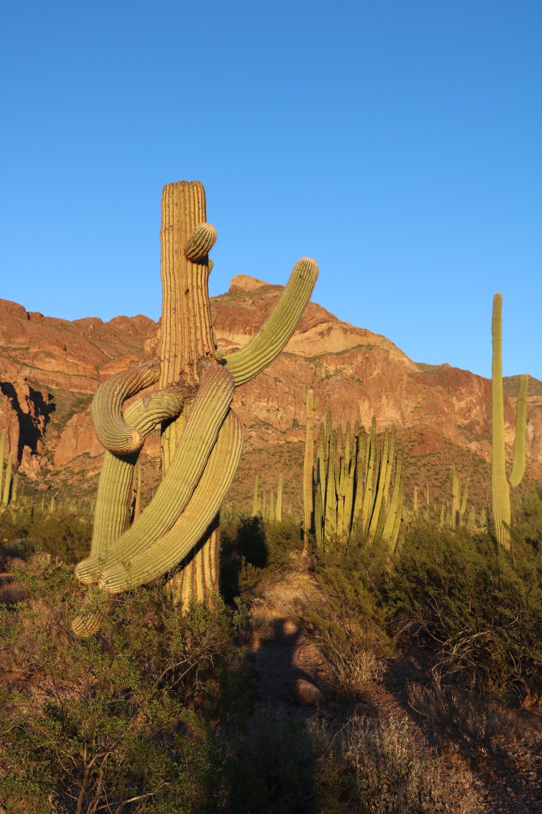
The hot, dry desertscape is embellished with these magnificent, old wizards.

A Saguaro 'Wizard'

The Saguaro can live up to 200 years and reach skyward to 45 feet. 

Dancing Saguaro


An Old Organ Pipe Sage
 

I can't get enough of these organ pipe cacti. Individuals live to be 150 years old on average. The thing does not even flower until its 35 years old. Before the government protected this area by establishing the Monument, Southern California scavengers were digging up these plant and others to sell to the hoards in LA.

Bizarre Organ Pipe Growth 


We head to the border to port of entry Lukeville, AZ (population 35) where we drive north on South Puerto Blanco Drive, but not before a border patrol office gives us a stern warning not to talk to anyone we may see in the area. 
We drive on dirt, gravel road for a few miles toward the Quitobaquito Hills and start thinking abut what it would be like to break down here, which prompted an immediate turn around. Along the way we see parts of an existing border wall, but President Bone Spurs is going to fix that sucker up.

Us and Them

Next up, Ajo Mountain Drive, a twenty-five-mile, dirt, gravel, washboard road eastward toward the Tonohono O’Odham Indian Reservation.

For thousands of years, The Tonohono O’Odham Indians lived throughout the southwest in an area now on both sides of the US Mexican border. Turns out, imagine this, the Indians are social beings who like to visit their friends, following religious and cultural traditions engrained in their DNA.

Big Problem, especially in the current political climate in American. The U.S. Border Patrol , especially in recent years, detains and deports these people regularly as they cross the border in these remote places. The Indians say the Border Patrol has occasionally confiscated cultural and religious items, such as feathers of common birds, pine leaves or sweet grass. Sweet grass?

Mount Ajo at 4,808 Feet

At the far end of the loop in Arch Canyon I make a new friend, Teddy the tarantula, whom Emily had no interest in meeting.

Teddy the Tarantula

Long slow drive. We make it back to our camp site, relieved, hungry and thirsty.

Cholla (sp) Cactus. Another Long Lived Desert Native

Saturday

Day #90. September 16 (continued).

“Woke up this morning, went into the kitchen, put on my slippers and died…” Wait that is another story by a different guy. I must have been dreaming.   We wake up at Hole in the Wall to the sound of a Scott’s Oriole ‘chucking’ at us. Nice touch, Mojave.

We see a black tailed jack rabbit shamelessly cavorting with a cotton tail. An integrated rabbit community here in California.  

After breakfast, we drive south on Black Canyon and Essex Roads to leave the Preserve, bound for the Organ Pipe Cactus National Monument in another famous western desert, the Sonoran. We take I40 east to Needles, CA on the Colorado River (population 4,844), then 95 to Vidal Junction, CA, which consists of a couple of gas stations, a trailer park, a closed diner and a billion head of cattle in expansive, confined feed lots. We smell Vidal long before we get there.
Route 62E takes us to Parker, AZ (population 3000) and through the Colorado River Indian Reservation and across the Colorado River. The reservation is home to Chemehuevi, Mohave, Hopi, and Navajo Native Americans.
We pick up route 72 and pass through Bouse (population 1000), Utting (population 126) and Vicksburg (population 600). Then east on I10 to Buckeye, Arizona (population 63,000). Don’t ask me why I insist on reporting population numbers. It’s what I do.

South from Buckeye on route 85 we pass through more captivating desert country to Gila Bend, AZ (population 1,900) where we watched Wile E Coyote cross the road. Further south we go to Ajo, AZ (population 3,500). Ajo is home to the New Cornelia Copper Mine, a sprawling one-thousand-foot-deep, mile and a half wide EPA superfund site. Superfund, as in bad news pollution. Although there is no active mining at Cornelia it’s still open because, get this, current owners say it’s too expensive to close, meaning clean up.   

Onward we go toward Mexico and finally to Why, AZ (population 116). Don’t ask me why they call Why Why. Nobody knows why town folk call Why Why!

Wile E. Coyote Looking for a Handout. 

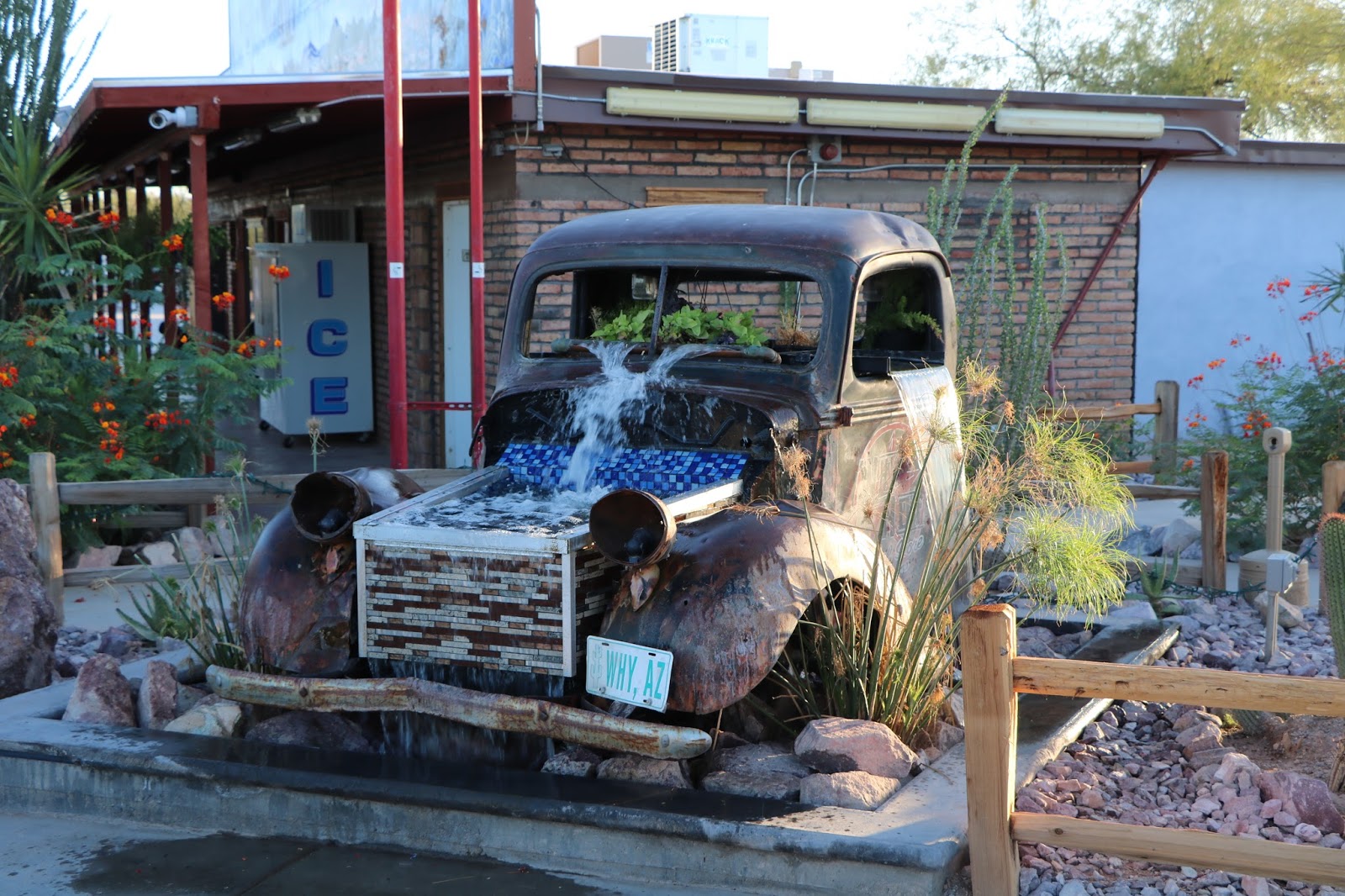
High Dollar Fountain

At a Texaco station in Why, we watch, mesmerized, as two coyotes calmly walk into the parking lot and start asking the few store clients for a piece of pizza.  An old ford truck sits at the station’s entrance with a fountain routed through it and a radio blaring out classic rock and roll alternating with stand-up comedy routines. Why not!  Its Why, AZ.


Finally, we are in the heart of the Sonoran Desert, one-hundred-thousand square miles of hot, dry country stretching from southwestern Arizona, southeastern California, across Baja California and the western half of Sonora, Mexico, with a whole lot of nothing in between.

Organ Pipe Cactus (Stenocereus thurberi), a 'Signature' Plant in this Region

The Mojave Desert lies to the north, in southern Nevada, extreme southwestern Utah and south eastern California. So now we have traveled in three major North American desert regions, the third being the Great Basin Desert in the northern three-quarters of Nevada, western and southern Utah, the southern third of Idaho and the southeastern corner of Oregon. There are various systematic classifications of desert types throughout the western US that note differences in flora, fauna, average rainfall and so on, but fundamentally the entire region west of the 100th parallel is arid.

Desertscape. Dry for Sure

To us traveling easterners lots of places we go out west look wet and even lush, but that is mostly because water developers transport water to those places from artificial impoundments via aqueduct and other means. San Francisco, for example, gets about twenty inches of precipitation a year and most of that between November and March. The rest of the year is bone dry. When Spaniards first arrived in these parts not a single tree grew there. Now the city sports a verdant urban tree scape all year, thanks to tunnels that transport water from reservoirs near Yosemite National Park, a hundred miles away.

The whole of the Sonoran is mining country, as are most of the western deserts through which we have driven. What else are you going to do in regions where the average annual precipitation in around ten inches. Many mines closed in recent years either because they played out or lost economic viability. All are potential, extreme pollution sources.On we go, pushing further south into Organ Pipe National Monument, driving through majestic, expansive, desert country, finally arriving at the Twin Peaks Campground, Site #33. No one else around. We have water, a sun canopy, nice clean restrooms and our very own solar, hot water showers, all for the outrageous price of ten bucks a night.


Our Very Fine Campsite in Organ Pipe Cactus National Monument


Free Insect Control Compliments of the National Park Service

A majestic Saguaro Cactus, Ocotillo and Creosote Bush at Sunset in Our Campsite 

Aho Mitakuye Oyasin, and good night.