Monday

Day #92. September 18.

Away we go north on 85 back to Why, AZ.

Why is Why, Why? you may ask. When Why didn’t have a name and a few earnest folks decided to live here, for what purpose I can’t imagine, highways 85 and 86 intersected in a Y. The local drunks, potheads, drug smugglers and other ne’er-do-wells lobbied for a post office, so they needed a town name. They had a meeting, smoked a doobie and offered up ‘Y’ as a logical choice. At the time Arizona required all cities to have at least three letters in their names, so the State vetoed ‘Y’. The townspeople took a pull on the tequila bottle and went to their second choice, ‘Why’, which the State approved. Since then, in its wisdom, the Arizona Department of Transportation removed the Y intersection for safety concerns.

With the Y intersection gone for a while, the good townsfolk forgot why Why is named Why. Your typical Why resident partakes of Mexican pot, tequila and cerveza often, which in and of itself creates a short term memory challenge. After all they do live in a desert where it rarely rains for months at a time and where daytime temperatures can soar to 110 degrees F. What else are you going to do to keep your mind clear? Bottom line, nobody can remember why Why is named Why. Which is why I am making up this story. And even if I didn’t make it up, I cannot remember why I didn’t.

At Why we take 86 E through the Tohono O’odham Indian Reservation, through Indian settlements; Schuchuli, Narcho Santos, Kui Tatk, Haivana Nakya, Pan Tak and others, all stuck out here in this hot, dry Sonoran Desert country. Mexico just a few scores of miles away. Many Border Patrol signs along the way issue warnings, cautions and advice, what to do and not to do when one sees ‘suspicious activity’, like dark skinned people walking across the desert on their way to visit friends and relatives and drug dealers.

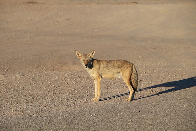
Soon after getting on 86 we see Wile E Coyote hightailing it down a dry arroyo (gulch). And, I’m not making this up, soon after that we saw a road runner darting along through the desert and I swear he was laughing.

On we go to Tucson where we pick up I10 east and drive to Lordsburg, New Mexico (population 2,800) where, during World War II, the US Army held fifteen hundred Japanese Americans in an internment camp for one year. During that time a US soldier shot and killed two Japanese American internees, under questionable circumstances as the story goes. A military investigation concluded that the sentry killed the two internees lawfully. Let me get this straight. Its lawful to uproot and imprison US citizens who have not been charged and convicted of a crime and shoot them for acting up a bit. Oh that's right. Martial law is lawful. How silly of me.

At Lordsburg we drive northeast for twenty miles on route 90 into the Gila National Forest where we went off road, avoided a wake of black vultures feeding on a deer carcass and found ourselves a nice free campsite all by ourselves for the night.

Sunday

Day #91. September 17.


Up early and away to explore this magnificent place.

Day Break in Organ Pipe

First up, Alamo Canyon. We drive five miles on gravel road to the only other camp site on the Monument, for tents only.

Alamo Canyon

The hot, dry desertscape is embellished with these magnificent, old wizards.

A Saguaro 'Wizard'

The Saguaro can live up to 200 years and reach skyward to 45 feet. 

Dancing Saguaro


An Old Organ Pipe Sage
 

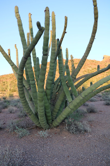
I can't get enough of these organ pipe cacti. Individuals live to be 150 years old on average. The thing does not even flower until its 35 years old. Before the government protected this area by establishing the Monument, Southern California scavengers were digging up these plant and others to sell to the hoards in LA.

Bizarre Organ Pipe Growth 


We head to the border to port of entry Lukeville, AZ (population 35) where we drive north on South Puerto Blanco Drive, but not before a border patrol office gives us a stern warning not to talk to anyone we may see in the area. 
We drive on dirt, gravel road for a few miles toward the Quitobaquito Hills and start thinking abut what it would be like to break down here, which prompted an immediate turn around. Along the way we see parts of an existing border wall, but President Bone Spurs is going to fix that sucker up.

Us and Them

Next up, Ajo Mountain Drive, a twenty-five-mile, dirt, gravel, washboard road eastward toward the Tonohono O’Odham Indian Reservation.

For thousands of years, The Tonohono O’Odham Indians lived throughout the southwest in an area now on both sides of the US Mexican border. Turns out, imagine this, the Indians are social beings who like to visit their friends, following religious and cultural traditions engrained in their DNA.

Big Problem, especially in the current political climate in American. The U.S. Border Patrol , especially in recent years, detains and deports these people regularly as they cross the border in these remote places. The Indians say the Border Patrol has occasionally confiscated cultural and religious items, such as feathers of common birds, pine leaves or sweet grass. Sweet grass?

Mount Ajo at 4,808 Feet

At the far end of the loop in Arch Canyon I make a new friend, Teddy the tarantula, whom Emily had no interest in meeting.

Teddy the Tarantula

Long slow drive. We make it back to our camp site, relieved, hungry and thirsty.

Cholla (sp) Cactus. Another Long Lived Desert Native

Saturday

Day #90. September 16 (continued).

“Woke up this morning, went into the kitchen, put on my slippers and died…” Wait that is another story by a different guy. I must have been dreaming.   We wake up at Hole in the Wall to the sound of a Scott’s Oriole ‘chucking’ at us. Nice touch, Mojave.

We see a black tailed jack rabbit shamelessly cavorting with a cotton tail. An integrated rabbit community here in California.  

After breakfast, we drive south on Black Canyon and Essex Roads to leave the Preserve, bound for the Organ Pipe Cactus National Monument in another famous western desert, the Sonoran. We take I40 east to Needles, CA on the Colorado River (population 4,844), then 95 to Vidal Junction, CA, which consists of a couple of gas stations, a trailer park, a closed diner and a billion head of cattle in expansive, confined feed lots. We smell Vidal long before we get there.
Route 62E takes us to Parker, AZ (population 3000) and through the Colorado River Indian Reservation and across the Colorado River. The reservation is home to Chemehuevi, Mohave, Hopi, and Navajo Native Americans.
We pick up route 72 and pass through Bouse (population 1000), Utting (population 126) and Vicksburg (population 600). Then east on I10 to Buckeye, Arizona (population 63,000). Don’t ask me why I insist on reporting population numbers. It’s what I do.

South from Buckeye on route 85 we pass through more captivating desert country to Gila Bend, AZ (population 1,900) where we watched Wile E Coyote cross the road. Further south we go to Ajo, AZ (population 3,500). Ajo is home to the New Cornelia Copper Mine, a sprawling one-thousand-foot-deep, mile and a half wide EPA superfund site. Superfund, as in bad news pollution. Although there is no active mining at Cornelia it’s still open because, get this, current owners say it’s too expensive to close, meaning clean up.   

Onward we go toward Mexico and finally to Why, AZ (population 116). Don’t ask me why they call Why Why. Nobody knows why town folk call Why Why!

Wile E. Coyote Looking for a Handout. 

High Dollar Fountain

At a Texaco station in Why, we watch, mesmerized, as two coyotes calmly walk into the parking lot and start asking the few store clients for a piece of pizza.  An old ford truck sits at the station’s entrance with a fountain routed through it and a radio blaring out classic rock and roll alternating with stand-up comedy routines. Why not!  Its Why, AZ.


Finally, we are in the heart of the Sonoran Desert, one-hundred-thousand square miles of hot, dry country stretching from southwestern Arizona, southeastern California, across Baja California and the western half of Sonora, Mexico, with a whole lot of nothing in between.

Organ Pipe Cactus (Stenocereus thurberi), a 'Signature' Plant in this Region

The Mojave Desert lies to the north, in southern Nevada, extreme southwestern Utah and south eastern California. So now we have traveled in three major North American desert regions, the third being the Great Basin Desert in the northern three-quarters of Nevada, western and southern Utah, the southern third of Idaho and the southeastern corner of Oregon. There are various systematic classifications of desert types throughout the western US that note differences in flora, fauna, average rainfall and so on, but fundamentally the entire region west of the 100th parallel is arid.

Desertscape. Dry for Sure

To us traveling easterners lots of places we go out west look wet and even lush, but that is mostly because water developers transport water to those places from artificial impoundments via aqueduct and other means. San Francisco, for example, gets about twenty inches of precipitation a year and most of that between November and March. The rest of the year is bone dry. When Spaniards first arrived in these parts not a single tree grew there. Now the city sports a verdant urban tree scape all year, thanks to tunnels that transport water from reservoirs near Yosemite National Park, a hundred miles away.

The whole of the Sonoran is mining country, as are most of the western deserts through which we have driven. What else are you going to do in regions where the average annual precipitation in around ten inches. Many mines closed in recent years either because they played out or lost economic viability. All are potential, extreme pollution sources.On we go, pushing further south into Organ Pipe National Monument, driving through majestic, expansive, desert country, finally arriving at the Twin Peaks Campground, Site #33. No one else around. We have water, a sun canopy, nice clean restrooms and our very own solar, hot water showers, all for the outrageous price of ten bucks a night.


Our Very Fine Campsite in Organ Pipe Cactus National Monument


Free Insect Control Compliments of the National Park Service

A majestic Saguaro Cactus, Ocotillo and Creosote Bush at Sunset in Our Campsite 

Aho Mitakuye Oyasin, and good night.


Friday

Day #89 – 90. September 15 - 16.


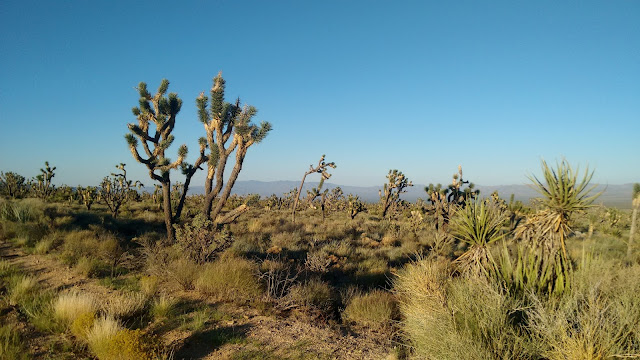
Woke up to a Wednesday morning with clear blue skies, not so hot today. Surrounded by desert mountains and a remarkable array of desert plants; creosote bush, barrel, prickly pear, chollas and organ pipe cacti and Joshua tree, soaptree and banana yuccas. Still looking for the peyote. 

Barrel Cactus with Baby

Cholla (sp)

Organ Pipe Cactus


We see black tail jack rabbits, cottontails, coyotes and red-tailed hawks during our stay.

Camping at Hole in the Wall. Our Own, Personal Honeypot. The Marl Mountains in the Background.


In the morning Master Sergeant Wan Mata (seventeen years in an Army Special Operations Unit) made a visit to our campsite and informed us that his unit was training in the area for deployment to Russia, Syria or Iraq.  He told us that several incognito agents would be circulating around doing whatever incognito agents do. He told us we would not recognize them as such. Since there isn’t anybody else around I suspect it’s a good bet that anybody we see will be an incognito agent.

We are the only people in the campsite and the immediate area, besides a bunch of twenty-year-old, testosterone-filled young men and possibly a few-estrogen filled young women; armed with pistols, M16A4’s, grenades and grenade launchers, machine guns, knives, shotguns, bayonets, claymore mines, anti-tank weapons and swords (just to be on the safe side). What could go wrong?

Master Sergeant Mata is an impressive man, a perfect gentleman and we enjoyed talking to him.

Later we meet the vivacious Sylvia Schreiber from Wickenburg, AZ who recently retired from a government job in Southern California, sold everything, bought a recreational vehicle, got herself a rescue dog, named it Lucky, moved to Wickenburg, bought herself five acres, parked the RV and now travels around in a little truck by herself, except of course for Lucky. She enjoys visiting the most remote areas she can find. She had just come into Hole in the Wall that morning. I think she is an incognito member of Master Sgt. Meta’s team!

Here we are, 2,700 miles from home, talking to a perfect stranger. We tell here where we are from. She says, “Is that anywhere near Polyface Farm?” “Absolutely, Joel Salatin is a friend", I reply. Sylvia claps her hands, does a little dance and shouts out her allegiance to Joel and the local food movement.  She thought we were celebrities. I didn’t say anything to disavow her from that notion. She told us that many people in Southern California and Arizona follow Polyface and Joel Salatin.

Another one of those small world experiences.

We decide to stay in this magnificent place for two days.

The Mojave National Preserve is a 1.6-million-acre unit of the National Park System, the third largest such system in the contiguous United States. All desert of course. Bone dry most of the time.

The Marl Mountains. See the Lava Bands.


It is filled with archeologic, natural and cultural wonders. Migrating sand dunes, cinder cones, lava beds and cliffs, volcanic plugs or domes, prominent mountain ridges and ghost towns. Summer temperatures go up to 105 degrees F. Annual precipitation varies from 3.37 inches to 9 inches. That is not a lot of water.

Volcanic Dome From Our Campsite


Preserve rangers strongly recommend four-wheel-drive on most of the roads, which limits us in visiting many of the wonders the Mojave has to offer. Lucky for us we can get to the campsite. But there’s enough easy road for us to get a feel. The Mojave warrants a future visit with a stouter vehicle.


Now that I'm old and retired I have decided to become a professional scatologist. I was very excited to examine my first exotic 'donation', but disappointed to learn from an amused park ranger that, "in these parts we call that good old western cow shit." Maybe I'll take up another hobby.
After a day's exploration we return to our campsite and enjoy a most delightful evening and night under a brilliant, starlit sky. Still no peyote. But I have some Evan Williams Black Label to see me through.
Good night friends.


Thursday

Day #88, September 14.


Today is a car maintenance day. Four new tires for the van at Big O Tire in Boulder City, Nevada.

We avoided Las Vegas and headed south on Interstate 15. Headed for another hidden American gem, the Mojave National Preserve in Southern California.


Mojave Desert

But first, we arrive at Primm, UT on the state line. Primm, an unincorporated community (population 436), boasts three mega-casinos that attract addicted gamblers coming from Southern California on their way to Las Vegas, who can’t wait. Primm sits in Invanpah Dry Lake, an actual dry lake bed, geologically speaking.


Pretty Much What One Sees for s Hundred Miles

Just to the south of Primm, in California we see the Ivanpah Solar Electric Generating System, the largest of its kind in the world, situated on four thousand acres of public land that used to be part of the range of the threatened desert tortoise. Before construction started on this facility, teams of wildlife agents removed all the desert tortoises they could find and relocated them. In other words, they evicted the tortoises from their little desert tortoise condominiums. Wildlife biologists say its likely that most of the transplants died.
Hold onto your hats you physicists and engineers out there.

The first thing one notices at Ivanpah is the three, 500-foot-tall solar towers, with light so bright you can see it from fifty miles away during the day. The tower light is ‘concentrated’ sunlight. This is no ordinary passive ‘solar panel’ (photovoltaic panel) farm.

Ivanpah generates power by using an array of 173,500 heliostats (each with two mirrors) deployed on the facility site. The heliostats track the sun, concentrates its light (of which there is plenty out here, being a desert and all) and beams it at the three solar towers that are equipped with sophisticated boilers.

Think about the times when you were a kid using a magnifying glass to burn leaves. Same physical principle at work here.

The towers convert the concentrated light (solar thermal energy) to heat in the form of superheated steam at 550 degrees Centigrade. That would be 1,022 degrees Fahrenheit. That steam drives a heat engine (steam turbine) that converts the heat to electricity, which electric utilities ship out to places like San Francisco and Los Angeles, so people can charge and power up their devices, Google the news, watch Netflix and order useless stuff from Amazon.

The facility ‘stores’ heat energy in molten salt for night time electrical production. Even so, the towers do cool as night goes forward so that, close to morning, stoned facility workers from Las Vegas fire up natural gas preheating elements to restart the boilers, to the tune of 525 million cubic feet of gas a year.

The facility cost 2.2 billion dollars. It opened on February 13, 2014. A couple of large energy companies invested a half billion dollars in the venture. Google invested three hundred million. Google has very big servers that need constant cooling. But Google has backed out of financing any more of these kinds of facilities because the cost of photovoltaic cells (solar panels) has come down so far that they predict solar thermal facilities like Ivanpah will not be able to compete with passive solar electrical production.

The United States government provided $1.6 billion in loan guarantees for this facility. That means east coasters like me are subsidizing the construction costs of an already obsolete energy plant that supplies electricity to casinos and brothels in California.

Lots of concentrated light beams traveling around at this facility; intense, concentrated, hot light. Guess what happens when a bird flies through an intense, concentrated, hot light beam. Immediate incineration, that’s what. Estimates vary as to number of birds killed at this plant from as few as 3,500 per year up to about 6,000. Doesn't sound like many but add that to the myriad of other ways we kill birds in America.

It is difficult to get an accurate number of how many birds human activity do kill in a year, given the dynamic nature of bird movement. Its not like counting stink bugs in your house you killed with Raid. People who study such things do estimates based on all manner of sources of information.

They estimate that window strikes alone kill between one hundred million and nine hundred million; communication towers, five to fifty million; high tension lines, up to one hundred and seventy-five million; cars, sixty million; pesticides, seventy-two million; feral cats, five hundred million; communication towers, five million. Fishing bi-catch, lead poisoning, oil spills, electrocutions kill lesser numbers.

That puts the relatively low Ivanpah bird mortality in perspective, although instant incineration can't be any fun. One would think OxyContin overdose would be more humane.


That Thing is Eight Feet Tall

On we go south to Wheaton Springs, CA (population 0) where we entered the Mojave National Preserve, intending to find the Preserve ‘Hole in the Wall’ Campground. After a twenty-five-mile run into the Preserve a washed-out road blocks our way so we backtrack fifty miles to Baker, CA (population 735). Here one finds the world’s biggest thermometer, a one hundred and thirty-four-foot monstrosity that commemorates the hottest temperature even recorded on Earth, 134 degrees F in nearby Death Valley on July 10, 1913. Americans sure are inventive. I wonder if people in other countries do strange stuff like this?

Baker is also home to at least four casino hotels and enough liquor stores to fill a battleship. Not much else in Baker except a few motels, which is exactly what we are looking for, exhausted from a long drive. We pick the Santa Fe. After a systematic and thorough evaluation, we determined that the Santa Fe is a rat hole and decide that Baker itself is a rat hole, so away we go backtracking again to the south for another ninety-miles to finally arrive at Hole in the Wall at 10:30PM.


View From Our Campsite. Hole in the Wall.

Whew!   Long day. But great camp site.

More on the Mojave Preserve tomorrow. Sleep well.

Wednesday

Day #87. September 13.


Woke up to another brilliant desert day. Drove out of gold Butte and marveled at the desert plants along the way.

Barrel Cactus and Soaptree Yucca

Teddy Bear Cholla

Cholla (sp.)

Desert Palm

Staghorn Cholla ?

Drove past the entrance to Juanita Springs Ranch on the way out. A cluster of desert palms might indicate a spring and oasis in this otherwise dry country. Hard to tell whether someone lives here currently.

Entrance to Juanita Springs Ranch

Desert Palm Oasis. Water Maybe?


We saw signs in the Bunkerville area for the ‘Bundy Ranch’. Did a little Googling and discovered that we were in spitting distance of the Cliven Bundy spread. Bundy, a cattle rancher in these parts, claims ancestral rights to public lands in the Bunkerville area, now managed by the Bureau of Land Management. Forget those pesky Paiutes who were here long before Bundy and his clan.
Bundy also claims the federal government has no constitutional right to own land, an assertion courts have repeatedly rejected. Bundy has a long history of over grazing his cattle on public land, causing substantial damage to the fragile desert ecosystem. For years he has refused to pay modest annual grazing fees. Now he is in arrears in the amount of one million dollars. Courts repeatedly have ordered him to pay up and remove his cattle from these publically held lands. To no avail. Bundy defied all orders. 

In March of 2014 BLM officials rounded up Bundy’s cattle to evict them from federal land. Bundy gathered his family and friends and, along with armed outside militia, staged a protest. Eventually the feds suspended the roundup and returned Bundy’s cattle to deescalate the situation. That just fired up the mob even more. They claimed victory in the ‘Bunkerville Wars’. National news reports showed militia members strutting about, brandishing their weapons and pointing them at federal officials.

Some of Bundy’s followers seized and occupied the Malhuer National Wildlife Refuge Oregon in January 2016. Federal employees were not able to go to work. The interlopers, in effect, closed the Refuge. Local people howled in rage and demanded that the federal government do something to rid their community of these thugs.

Eventually law enforcement officers tried to arrest Robert LaVoy Finicum, the leader of the thugs. Finicum resisted and state troopers shot and killed him as he moved his hand toward his pocket where officers later found a loaded weapon.

Eventually the feds arrested Bundy and many of his 'associates'. They charged him, his sons and many others with multiple federal offences. Bundy spent some time in prison while the legal process snail walked along. In January of this year a federal judge dismissed all charges against Bundy. So now he can go back to over grazing his cattle on public land, destroying natural assets, not paying his grazing fees and flipping the bird at federal officials as they ride by his ranch.

So much for the rule of law.

We cross the Virgin River and pick up Interstate 15, southbound and turn onto Route 169 to Overton, on the west side of Lake Mead.

We drive south along North Shore Road through the Lake Mead National Recreation Area with the Lake to the east. More splendid desert scenery. Dry, dry, dry! Very little traffic. Along this drive one finds several natural springs. We stopped at one and have lunch.

Rare Desert Spring. Don't Drink the Water. Loaded with Brain Eating Protozoans.


Lakeshore Road intersects with route 93 that takes us to the monstrous Hoover Dam.

Looking Down Hoover Dam's 726 Foot Face


Hoover backs up the Colorado, Muddy and Virgin Rivers in Black Canyon and Boulder Canyon to form Lake Meade, the largest man-made impoundment in the US, when its full, which it rarely is. The Bureau of Reclamation built the dam in 1931 through 1936. Contractors paid thousands of workers a few dollars a day to labor on the dam. Over a hundred of them died in the effort. The contractors would not hire Chinese workers and allowed about thirty black folk on the job, paying them lower wages than the whites. The boss man issued separate water buckets to the blacks so as not to contaminate white worker’s water.

Massive Spillway


You could drive a locomotive through that spillway. Its never been used, which ought to tell you something. That is, it rarely rains out here.


It was tough times in America. Dust Bowl days. All those dirt farmers in the Midwest who had dutifully plowed their land because they believed if they did the rains would come, which of course they didn’t. Not surprising since they were plowing a desert.  The poor dirt farmers and their families sadly watched their newly plowed fragile top soil turn into dust and blow away in the hot dry Midwestern winds. With no recourse and no prospect for employment at home, between 10,000 and 20,000 desperate people converged on Boulder City seeking employment on the dam. Squatter settlements grew up at the dam site and the whiskey flowed copiously. The flimflam artists and prostitutes showed up in force. Party time.

Boulder Canyon Upstream from the Dam. 

Standing on top of the Dam Looking Down 1000 Feet to the Colorado River

Hover Dam is 726 feet high, 660 feet wide at the base and 1,244 feet across at the top. It weighs 6.6 million tons and contains four and one-half million cubic yards of concrete. Its super high capacity generators supply power for public and private utilities in Nevada, Arizona and California. Ironically, Hoover is generating less electricity than in the past because of falling water levels in the lake which decreased hydraulic head which reduces power generation.

After all this is a desert.

If the water falls far enough electrical generation will stop all together. Never fear. As we speak engineers are installing new, more efficient turbines at different pool levels to take up the slack. How low can you go?


The impounded water goes to nearby Boulder City and Las Vegas.

After our Hoover visit we drove to Boulder City Nevada and check into a best Western Motel for much-needed showers and laundry.

Oh my, those underwear!

Tuesday

Day #86. September 12. Gold Butte National Monument.


We follow the Virgin River to La Verkin (population 4000), Hurricane (population 13,800) and Harrisburg Junction, where we picked up Interstate 15 to Washington (which grew from 8,200 in 2000 to 18,800 in 2010). They grow cotton here of all things, thanks to water drawn from the Virgin River. St. George is next (population 82,000). Lots of Mormons. St. George sits on convergence of three distinct geological areas: the Mojave Desert, Colorado Plateau, and Great Basin.

Traveling through the Mojave Desert we see more splendid desert country. Pass through Littlefield, AZ (population 308) and finally into Mesquite, NV (population 17,500) and growing. Mesquite has casinos, golf courses, retirement homes, lots of physical therapists, very big and well stocked liquor stores, lots of rich retired old people and no water. 
Mesquite is also the home of the monster Stephen Paddock who murdered fifty-eight people at a concert in Las Vegas on October 1, 2017, the deadliest mass murder in US history. It took him ten minutes to indiscriminately fire 1,100 rounds into the crowd wounding another 851 people.

It is very likely that this depraved man was in Mesquite when we passed through.

We stock up on whiskey. Easy and cheap what with a respectable number of brimming over whiskey stores. Water is another matter.

Later today we want to travel to another gem of a natural area, the Gold Butte National Monument, just southwest of Mesquite where there is no water for miles and the temperature this time of the year soars to 110 degrees.
In Mesquite we visit four gas stations, the visitor center and a library. All the water faucets have locks on them and business proprietors say no to a request for water. That ought to tell you something.

However, we visit the local fire and rescue station. The guys on duty there were quite accommodating and happy to help us out. They filled our tank with good artesian well water and sent us on our way with a warning to be careful in Gold Butte.

Notwithstanding the warning, away we go to Gold Butte on route 170, through Bunkerville (population 1,300), still following the Virgin River. Not much water there. Not much water anywhere, except for Lake Mead to the southwest, created by the monstrous Hoover Dam.


Entering Gold Butte National Monument. Beware.


Gold Butte National Monument, a three-hundred thousand acre desert preserve contains a wide array of natural and cultural resources; including ancient rock art, sandstone towers, and important wildlife habitat for species like the threatened Mojave Desert tortoise. Good old Barack Obama, at it again, designated this area in 2016 after local conservation groups, Nevada and Clark County lawmakers and the Moapa Band of Paiute Indians mounted a vigorous campaign to encourage him to do so. Those pesky Paiutes at it again.

Note the local effort to protect this area. Republicans in Congress oppose it of course and call for revocation of the designation.

Weird Gold Butte Rock Formations.


Nobody lives here now. It’s too hot and dry. There are few mineral resources to speak of. In the late 19th and early 20th centuries some brave souls tried to ranch and farm here. They built water catchment basins, but drought eventually chased them out. There is a ghost town, gold Butte, but all the remains are some mine openings, a few seamen foundations and a few pieces of rusty equipment.

Eastern Greenhorn in Front of a Dam Catchment Structure. Dry as a Bone.

Prior to the area’s designation as a national Monument, local people reported substantial damage to abandoned historic cultural resources (historic corrals and fences), felled Joshua Trees (not a tree at all, but a local Yucca) and, tragically enough, 10,000-year-old petroglyphs peppered with bullet holes.

We leave route 170 and take Gold Butte Road, turn to the south east away from the Virgin River, and drive for 15 miles on dirt gravel washboard roads, averaging 5 miles an hour. The temperature is 109°. This is the Mojave Desert at its best. Nobody around except us back east greenhorns. Rock, sand, cacti, palms and yucca as far as you can see.

Driving into Gold Butte


We reach the end of the line for us at Whitney Pockets, a series of red sandstone cliffs, towers and monoliths. Roads beyond this point are too rough for our intrepid, two-wheel drive, Dodge Grand Caravan.

Camping at Whitney Pockets


Wind Tortured Whitney Pocket Sandstone 

Late Day at Whitney Pockets

But this is perfect. We are by ourselves in the middle of a grand desert landscape. We set up our camp and wonder around the local landscape marveling at the desert ecology and the weird and fascinating rock formations. The hot dry desert panorama is all ours.
All alone we watch night come on. Brilliant, starry sky. Coyotes yipping in the distance. Hot air. Pleasant enough though. 
Good night America.